Lake2Lakes Ride Details
This ride is a joint CATS and COWS ride.
A CACTUS ride - CATS And COWS Tandeming in Unison with Style!
Date: Aug 3, 2024, Saturday
Time: 9:00 AM
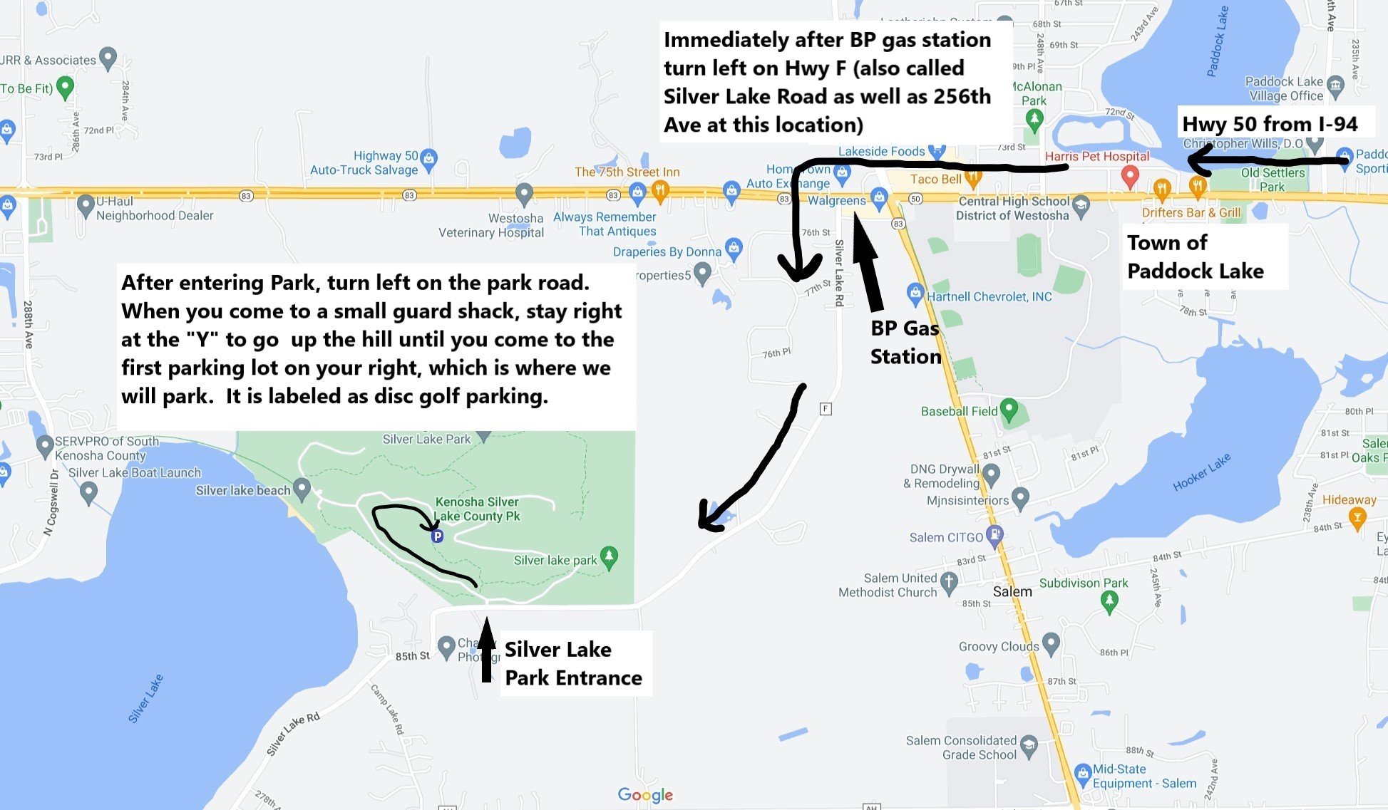
Start Location: Silver Lake County Park. 27000 85th St, Salem, WI 53168. We will meet at the disc golf parking lot in Silver Lake Park. See “Directions to Parking Lot” map at the bottom of this page for directions to the parking.
Event Leaders: Greg and Jeanne Browning for CATS, Pat and Beth Peterson for COWS
Event Leader Contact Phone : 224-430-3314
Event Leader Email: gregandjeannebrowning@gmail.com
RSVP: Use the appropriate link button below depending on whether you are, or are not, a CATS club member. All riders are encouraged to become members, but non-members are allowed to “try out” a ride or two before deciding if they want to pursue membership.
Event Description: This is a CACTUS ride - CATS and COWS Tandeming in Unison with Style! (A jointly sponsored CATS/COWS ride.) The ride visits four lakes in SE Wisconsin. Approximately 1/3 of the route goes through lakeside neighborhoods and 2/3 of the route is on country roads connecting the lakes. Most of the country roads are low traffic, but there are a few stretches with moderate traffic. The route is a mix of hills and flat sections. There are a few short steep grades. The 45 mile route visits all four lakes, while the 29 mile option cuts out Bohner Lake. The ride begins at Silver Lake Park, visits Silver Lake, Twin Lakes, Powers Lake, and Bohner Lake before returning to Twin Lakes for lunch at Wild Child’s Restaurant and ice cream at Tom’s Straw Hat. We then we ride the final seven miles back to the cars at Silver Lake.
RWGPS: Routes can be found on the CATS RWGPS site.
The RWGPS mobile app may be used for turn-by-turn Voice Navigation after opening the route on the app.
Also, a desktop computer can be used to download GPS files and cuesheets from the CATS RWGPS site.
- On a desktop computer, find the route you need in the Route Library on the CATS RWGPS site and click on the route to open it. Once the route is opened, you can click “More” in the upper left corner for options to export GPS files and cuesheets. A drop-down menu appears allowing you to “Export as File” (which opens a box for you to select your preferred GPS format of FIT, TCX, or GPX). The drop-down menu also has options to “Print Map and Cue PDF” or just “Print Cuesheet.”
IMPORTANT - DO NOT DOWNLOAD FILES UNTIL A FEW DAYS BEFORE THE RIDE AS THE ROUTE MAY BE UPDATED PRIOR TO THEN !!!
Ride Start Location
Directions to Parking Lot